
Power of the Crowd: Citizen Science
by NOAA Fisheries 22 Apr 2018 14:33 UTC
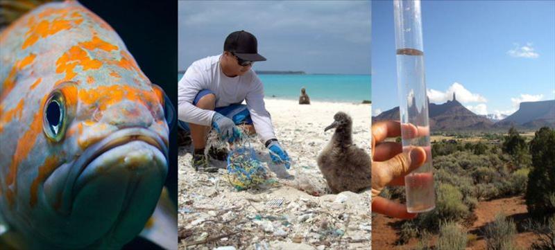
Power of the Crowd: Citizen Science © NOAA Fisheries
The National Weather Service's origins date to the early 1800s when new access to the telegraph allowed weather reports from distant areas to be collected, plotted and analyzed at one location. By 1849, 150 volunteers across our young nation were submitting local reports to an increasing number of stations.
This network has never stopped growing. Today many thousands of volunteers provide near real-time weather and climate observations. They report from every part of the country, often daily, and from one generation to the next.
Collaborating with many partners, NOAA's Office of Education and offices across NOAA continue to make citizen science a vital part of observing, predicting and protecting our environment.
Citizen science helps address societal needs; cost-effectively enhances research and monitoring; provides authentic learning experiences; and connects the public to NOAA's mission.
Each year citizen scientists volunteer more than 500,000 hours to over 40 projects involving NOAA and our partners.
Here is a look at their stories:
"Delisting" success
Between 2014-2016, charter boat captains and 100 volunteer anglers collected 100 rare rockfish in the Northwest's Puget Sound region. Three species had been listed as threatened or endangered, and NOAA looked to local ecological knowledge for the scientific sampling required for recovery.
Genetic analyses from these fishing trips provided new information and contributed, in 2017, to the delisting of Canary Rockfish and expanded protective boundaries for Yelloweye Rockfish.
Monitoring marine debris
Marine debris research and education are getting a boost from the Marine Debris Monitoring Toolbox, which NOAA partners and volunteers are using to conduct monthly surveys of nearby shorelines and waterways. Results are logged in a NOAA database.
There is a toolkit for educators and a Marine Debris Tracker that allows trash to be tracked, characterized and logged from anywhere.
Measuring precipitation
Whenever rain, snow or hail falls in an area, CoCoRaHS volunteers measure and map the amount, giving those who require these data an increasingly clear and online picture of precipitation totals and locations.
CoCoRaHS (ko-ko-rozz) is the acronym for the Community Collaborative Rain, Hail & Snow network.
Using low-cost tools, more than 20,000 volunteers across all 50 states provide on-the-ground data in real-time for NOAA forecasters, farmers, emergency and water resource managers, and numerous others to analyze and apply.
Clues to future climate
Everyone can join in this effort to help scientists better understand long-term changes in the Arctic. Although geographically remote, these changes have significant global reach.
Through the "Old Weather" project, thousands of citizen scientists with highly diverse backgrounds and interests are recovering millions of weather and environmental records from historical ship logs and other documents and converting them to digital formats. The information is then integrated into large-scale datasets supporting analyses of centuries of Arctic and global change.
These analyses help predict far-reaching future change and its human and environmental implications.
Steller Watch
In the past 30 years, Steller sea lions in Alaska's remote western Aleutian Islands have nearly vanished.
To understand why, NOAA staff marked a small number of sea lions to track movements and survival throughout their lives. But given the remote locations, sightings are difficult.
Steller Watch's online volunteers help tackle this challenge by classifying images captured by remotely-stationed cameras. In just one year, they have classified 340,000 images, carefully viewing each multiple times for a total of three million views. By narrowing sea lion images to just those with readable marks, citizen scientists have already saved NOAA Fisheries hundreds of viewing hours.
mPING app
If hail is hitting your roof, or snow is blanketing your drive, NOAA forecasters want to know. With the free mPING app, that's easy to do. Anyone, anywhere can report conditions via mobile devices.
mPING is the acronym for Meteorological Phenomena Identification Near the Ground.
Since radars can't "see" on the ground, the information helps meteorologists fine-tune weather forecasts, especially those related to road maintenance, aviation operations and public warnings. The data also help shape new radar and other forecasting technologies.
Reports can be submitted minute-by-minute. They are then shared on a public map.
Ocean Video Lab
Ocean Video Lab's new portal opens an amazing underwater world to citizen scientists, enabling them to explore remote areas of the ocean. Viewing many hours of video collected on ocean expeditions, volunteers thematically bookmark content, saving time for scientists.
Rather than viewing a full dive, for example, a biologist specializing in corals can jump right to a bookmarked coral site. A geologist can advance quickly to footage of faults.
Scientists' detailed annotations build on the general notes of volunteers, greatly enhancing the efficiency of ocean exploration.
Crowdsourced bathymetry
Bathymetry, knowledge of the seafloor's depth and shape, is vital to safe, sustainable and cost-effective activities at sea. Yet much of our nation's seafloor remains unmapped and unexplored.
NOAA and industry are collaborating to help fill this gap and have already provided over 80 million measurements from more than 100 fishing and recreational boats, cruise ships, tankers and tugboats. The vessels log data, which is transmitted to NOAA and then made public.
The crowdsourced data identify uncharted features, help confirm the accuracy of existing charts, and provide an efficient way of determining where rigorous surveys are needed.
SKYWARN®
SKYWARN® severe weather spotters give their communities the gift of time – crucial minutes and seconds of lead time that save lives.
More than 350,000 National Weather Service-trained volunteers from all walks of life help protect their communities with timely reports of hazardous weather, especially severe local storms.
Along with Doppler radar and improved satellite and other data, spotters enable NOAA to issue more timely and accurate warnings for tornadoes, severe thunderstorms and flash floods. In most years, such events cause hundreds of injuries and deaths and billions in property and crop damage.
Channel Islands Naturalist Corps
Watching marine mammals provides greatly added value in Southern California where a corps of 150 trained volunteers identifies marine mammals and educates the public during local excursions.
Using a Whale Alert app that feeds into a marine mammal database, citizen scientists detail sightings in near-real time. Volunteers record sightings of nearly 30 species, including endangered blue whales and humpback whales.
An analysis of whale sightings and travel patterns into Santa Barbara Channel led to modified ship routes, reducing the threat of ship strikes to large whales.