
C-Map releases North Carolina Precision Contour HD Chart
by Andrew Golden 12 Jul 2019 21:32 UTC
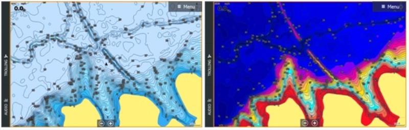
C-Map releases North Carolina Precision Contour HD Chart © C-Map
C-MAP®, a leader in digital marine cartography and cloud-based mapping, announced today the release of a new chart card in its series of digital fishing map cards, Precision Contour HD - North Carolina.
Precision HD cards feature highly detailed 1-foot contours, high-resolution satellite imagery and C-MAP's one-of-a-kind Custom Color Depth Shading, as well as fishing and navigational Points of Interest. The card is exclusive to chartplotters in the Navico portfolio of brands (Lowrance®, Simrad® and B&G®).
"We are excited for our customers to get their hands on the new Precision Contour HD chart card for North Carolina," said Knut Frostad, CEO, Navico. "The unrivaled detail of our Precision Contour charts makes it easier for anglers to find productive water, so they can spend more time fishing and less time searching for key fishing areas."
The C-MAP survey fleet includes shallow-draft boats with surface-drive motors, enabling comprehensive coverage of every popular and important fishery in each state covered. Surveyed coverage includes most of the skinniest distant creek arms and shallowest backwaters, as well as key, fish-holding offshore structure like humps and holes, reefs and shoals, ledges and breaklines, sunken islands and points.
Precision Contour HD charts also feature C-MAP's Custom Color Depth Shading* functionality, which enables anglers to highlight specific areas of interest, including current fish-holding depths and potential hazard areas. Custom Color Depth Shading also enables adjustments to the chart display to reflect high- or low-water conditions that can affect the shape and edges of shorelines and submerged or partially submerged structures. Additional map-display features include four pre-set, depth-shading palettes, including Safety Shading.
The North Carolina chart covers the following C-MAP-surveyed waterbodies, as well as traditional data on other lakes in North Carolina.
| C-MAP-Surveyed Waterbodies |
|---|
| B Everett Jordan | Shearon Harris | Gaston Lake |
| Wylie | John H Kerr (Buggs Island) | Fontana |
| Falls Lake | Tillery | Hickory |
| High Rock | | |
The following are North Carolina lakes featuring high-definition, non-surveyed, 1-foot contours.
| High-definition, Non-surveyed Lakes |
|---|
| Phelps Lake | Hiwassee | Brier Creek Reservoir |
| Sweet Creek | Echo | Hyco |
| Oak Hollow | Cedar Cliff Lake | Tanasee Creek |
| Buddle | Mayo | Lake Brandt |
| Country Club Lake | Panther Lake | Fly Rod |
| Townsend | Michie | Atagahi Lake |
| Comptons Pond | Hoffman | Mackintosh |
| Roxboro | Ticoa | Shadow |
| Little Juniper | White Lake | Julian |
| McArthur | Big Juniper | Deep River |
| Apalachia Lake | High Point City | Raleigh |
| Williamsburg Wildlife Lake | McGuire Station Pond | Surf |
| Silver Run Lake | Big Lake | Symphony |
| Jeanette | Auman Lake | West Fork Lake |
| Harper Hearn | Mintz Pond | Wheeler |
| Quaker Creek | Sequoia | St. Mathews |
| Simmons | Allen Polishing Pond | Ski Pond |
| Belews River Bend | Gordon | Spring Valley |
| Blues | Higgins | Tar River Reservoir |
| Boykin Bridge | Kiest Lake | Varda |
| Buckhorn Reservoir | Little Northeast Creek | Waccamaw |
| Cary | Lochmere Small | Whisper |
| Crabtree | Mott Lake | Allen Ash Basin |
| Echo Lake (Seven Lakes - Number 1) | Pine Lake | James |
| Falconbridge | Red Lake Number Two | Sand Pit Pond |
| Forest | Salem Lake | Belews |
| Brunswick Plantation Pond (A, B, D, E, F, H & K) | Brunswick Plantation Pond (18, 22, 24, 31, 33, 34 & 35) | Magnolia Greens Pond (1-3, 5, 6, 9A, 10, 11, 15, 20, 23 & 28) |
The C-MAP Precision Contour HD - North Carolina chart card is compatible with most Lowrance, Simrad and B&G chartplotters and is available for $149 USD. Purchase of the card includes a free one-year subscription to C-MAP's Genesis Edge custom mapping service. For more information on the new Precision Contour HD charts, please visit lowrance.com.
*Custom-Color Depth Shading is compatible with Lowrance HDS Gen 2, HDS Gen 3, Carbon, HDS LIVE and Elite Ti and Elite Ti2 units. It is not compatible with Lowrance HOOK, Lowrance Elite HDI, Elite CHIRP or Elite DSI units.