
C-MAP releases new chart for Lake Hamilton
by Andrew Golden 15 Feb 2018 05:26 UTC
C-MAP new chart for Lake Hamilton © Andrew Golden
C-MAP, a leader in digital marine cartography and cloud-based mapping, announced today the release of a standalone C-MAP Genesis card containing a one-foot contour map of 7,200-acre Lake Hamilton, one of Arkansas' most-productive bass fisheries. The new Lake Hamilton chart will help anglers catch more and bigger fish with game-changing features like Custom Color Depth Shading and a bottom-hardness layer.
"Having the best map is a critical factor in fishing today," said Candler McCollum, United States sales manager, C-MAP. "This new C-MAP chart provides the most accurate and high-definition contour data ever seen for Lake Hamilton. The addition of a bottom-hardness map will give bass anglers on the lake a huge advantage."
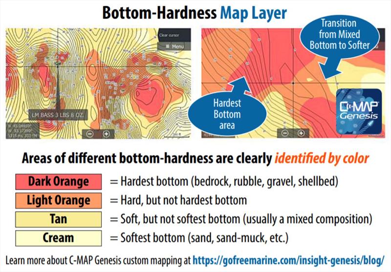
Unique Bottom-Hardness Map
Toggling on the bottom-hardness layer will help Lake Hamilton anglers easily find and target the most-productive areas on structures such as points, ledges and humps. Gamefish often feed around hard-to-softer-bottom transitions on such structure. Areas of different bottom hardness are clearly identified by different colors in the layer, showing the size, shape and location relative to one-foot contours of the surrounding structure.
Custom Color Depth Shading
The new Lake Hamilton chip is also compatible with C-MAP's unique Custom Color Depth Shading feature. Anglers can select from 16 colors to highlight as many as 10 customized depth ranges. They can set two separate custom-color depth palettes for every map. Humps and holes, reefs and shoals, drains and ditches, ledges and breaklines will all be much more visible when set apart by Custom Color Depth Shading.
C-MAP Lake Hamilton Charts are available for $100 USD. For more information on C-MAP Lake Hamilton Charts, please visit www.c-map.com.